I have spent the last hour or so looking over models trying to get a consensus of the approaching weather system. It seems like the consensus is the system will be dryer, but more widespread.
As of now the charts have been implying this, but it looks like the northwest part of Franklin County will get the greatest amount of impact with .1″ to .3″ inches of ice expected. The southeastern part of the county is expected to receive less that .1″ of ice. The places in between will receive .1″ to .2″ inches of ice.
The freezing line and amount of precipitation that we receive we exactly do not know until it gets on top of us. There is a strong chance we are going to get ice tomorrow. Today is the time to prepare.
This is something that we will not be in for several days as of yet, it ought to be something that we should prepare for a Friday at home and some brief power outages.
It is 69 degrees as we speak. Temperatures will be falling till around 40 by nightfall. The low is supposed to be 29 this evening. The changeover from rain to freezing rain will take place between 10 pm to 12 pm.
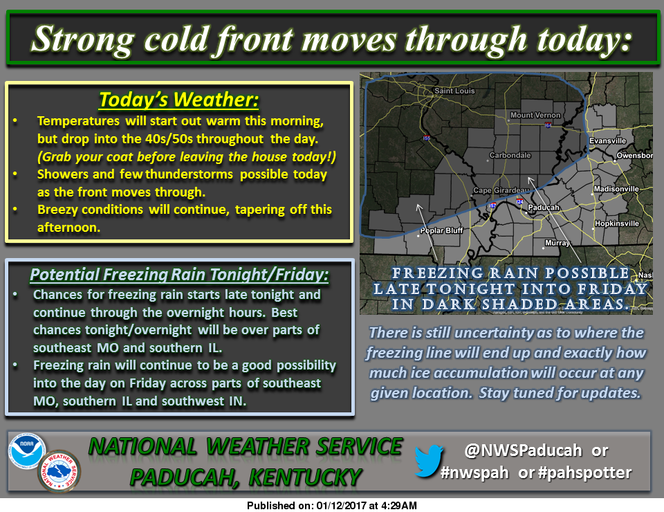
Here is the products that have been issued by the National Weather Service for Franklin County-
SPECIAL WEATHER STATEMENT…GUSTY WINDS TO CONTINUE THIS MORNING…FREEZING RAIN LIKELY FRIDAY…
Freezing rain appears likely Friday across portions of southeast Missouri, southern Illinois and southwest Indiana. The activity could develop into the area before daybreak. It is expected to increase Friday morning, and last through the afternoon and then taper off. Confidence continues to increase the freezing air will make it as far south as a Greenville Missouri, Marion Illinois, Princeton Indiana line.
There may be some impacts to travel, especially on bridges, overpasses, and secondary roads. Sidewalks and parking lots may become quite slick as well. Elevated surfaces will ice. Expect a glaze on automobiles. Impacts to power should be minimal.
Meanwhile this morning, southwest winds will gust from 25 to 35 mph at times. This will cause loose objects to blow around. Travel may be difficult for some high profile vehicles. A cold front will move through this morning and early afternoon from north to south across the area. Winds will shift to the northwest and decrease behind the front.
THIS HAZARDOUS WEATHER OUTLOOK IS FOR PORTIONS OF SOUTHERN ILLINOIS, SOUTHWEST INDIANA, WESTERN KENTUCKY, AND SOUTHEAST MISSOURI
. .DAY ONE…TODAY AND TONIGHT A FEW ISOLATED THUNDERSTORMS WILL BE POSSIBLE TODAY. WINDS WILL GUST 25 TO 35 MPH THIS MORNING.
FREEZING RAIN WILL BE POSSIBLE LATE TONIGHT AND INTO THE OVERNIGHT HOURS ACROSS PORTIONS OF SOUTHEAST MISSOURI AND SOUTHERN ILLINOIS
. .DAYS TWO THROUGH SEVEN…FRIDAY THROUGH WEDNESDAY FREEZING RAIN WILL CONTINUE TO BE A THREAT AS WE HEAD THROUGH THE DAY ON FRIDAY ACROSS PORTIONS OF SOUTHEAST MISSOURI, SOUTHERN ILLINOIS AND PARTS OF SOUTHWEST INDIANA. FREEZING RAIN IS POSSIBLE GENERALLY NORTH AND WEST OF A LINE FROM POPLAR BLUFF MISSOURI TO EVANSVILLE INDIANA. THE HIGHEST ICE ACCUMULATIONS ARE EXPECTED NORTH AND WEST OF A LINE FROM GREENVILLE MISSOURI TO CARBONDALE AND MOUNT VERNON IL.
THUNDERSTORMS ARE POSSIBLE ON MONDAY AND MONDAY NIGHT…THEN AGAIN TUESDAY NIGHT THROUGH WEDNESDAY MORNING. NO WIDESPREAD SEVERE WEATHER IS EXPECTED. LIGHTNING AND LOCALLY HEAVY DOWNPOURS WILL BE THE PRIMARY HAZARDS. THIS PROLONGED PERIOD OF OFF AND ON RAINFALL MAY RESULT IN STANDING WATER IN LOW LYING AND POOR DRAINAGE AREAS…ALONG WITH POSSIBLE RISES IN SMALL CREEKS AND STREAMS.
Here is a link to the seven day forecast in Franklin County:
orecast.weather.gov/MapClick.php?map.x=176&map.y=89&site=pah&zmx=1&zmy=1#.WHeC8NQrJxA
We will keep the social media page updated with new charts and graphs issued. If there is an advisory or a Winter Storm Watch issued for Franklin County will put this on the website as well as an updated closing and cancellation thread if it warrants.


Speak Your Mind
You must be logged in to post a comment.